


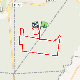
20160216-Conbourg

doudet
User

Length
7.6 km

Max alt
128 m

Uphill gradient
94 m
Km-Effort
8.9 km

Min alt
64 m

Downhill gradient
93 m
Boucle
Yes
Creation date :
2018-09-11 09:11:53.602
Updated on :
2018-09-11 09:11:53.602
1h56
Difficulty : Very easy

FREE GPS app for hiking
 SityTrail
IGN / Geographical institutes
SityTrail Plus
The world is yours!
About
Trail Walking of 7.6 km to be discovered at Normandy, Eure, Les Damps. This trail is proposed by doudet.
Photos

Positioning
Country:
France
Region :
Normandy
Department/Province :
Eure
Municipality :
Les Damps
Location:
Unknown
Start:(Dec)
Start:(UTM)
367203 ; 5461031 (31U) N.
Comments